
Russian Town Puts Giant Smiley On Google Maps 280
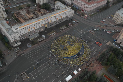
Toramir writes "Citizens of the Russian town Chelyabinsk calculated when the satellite, QuickBird, which takes images for Google Earth and Google Maps, would cross above their city and used people to make a giant smiley face. A rock concert on the main square attracted many people and everyone got a yellow cape. It looks like someone at Google was quicker than usual to put up the new data. Maybe Google likes the idea of an entire town working hard to get its 15 minutes of fame. The article has a screenshot of Google Maps and images taken directly at the event."

But where is it? (Score:3, Informative)
I don't see it on Google Maps:
http://tinyurl.com/butwhereisit [tinyurl.com]
Up close and personal - the long version:
http://maps.google.com/maps?f=q&hl=en&geocode=&q=+Chelyabinsk+&ie=UTF8&ll=55.159908,61.402202&spn=0.001906,0.005686&t=h&z=18&iwloc=addr [google.com]
Re:Where exactly? (Score:5, Informative)
Re:Where exactly? (Score:4, Informative)
Fake images (Score:4, Informative)
You can see the search used in the image. Search for for 'Tscheljabinsk, russia' and zoom in. You can see that you end up in the same square, but there is no smiley there!
Also: cars were removed from the image close to the square, but they're in the same locations further away. Light hits the image from the same angle, which means same time and date difference from equinox).
ÐzÑÐнÑOE Ñ...& (Score:5, Informative)
It's a bad photoshop (Score:5, Informative)
Compare these two:
http://4.bp.blogspot.com/_IeJHb-2CVGM/SNUFiyTlEHI/AAAAAAAAAIQ/shQMNh5h89o/s1600-h/smiley-1000.jpg [blogspot.com]
http://maps.google.com/maps?q=tscheljabinsk+russland&ie=UTF8&oe=utf-8&client=iceweasel-a&t=h&ll=55.160037,61.403425&spn=0.004793,0.011179&z=17 [google.com]
The cars on all the side streets and all the shadows are exactly the same. Someone just photoshoped out the cars on the main street and put in the smily. Nothing to see here.
Re:Fake images (Score:5, Informative)
Furthermore the fake screenshot depicts the very exact same thing as the rooftop picture. What's more pathetic, that they actually did it but not for when Google would actually shoot (is there even any way to actually know that?) or that the Slashdot "editors" didn't even see that coming.
I guess that's Journalism 2.0, in which it's the user who does the editor's job of spotting the bullshit.
Yes, Lenina (Score:5, Informative)
If a town or a street got renamed during the Soviet period, after 1992 its name was in most cases restored to the pre-revolutionary version. However, if the street was built during the Soviet period, of course it would not get renamed, since it never had a pre-Soviet name in the first place. Renaming a street just because its name is no longer politically fashionable is akin to rewriting history, no better than what the Soviets were doing.
Re:It's a GOOD photoshop (Score:3, Informative)
Fooling a /. "editor" doesn't make it a good photoshop. It took me about a second to realize it was a hoax, and less than 30 more to look up the above link. I guess that was a bit too much effort for samzenpus.
Re:Lenina? (Score:5, Informative)
Anyway, almost every city in Russia still has Sovetskaya street and the Lenin square (complete with a statue). My own home town, Tambov, also has Karl Marx street, Komsomolskaya street etc. Some streets that were named after the more odious figures were renamed in the 90s (one was named after Antonov-Ovseenko, who was the commissar in charge of suppressing the anti-communist Tambov peasant rebellion in 1920s, and personally signed the order to use poison gas against the rebel), but most of the "generic" names were left untouched.
Re:Here's an example of the real thing (Score:3, Informative)
It's not for the sake of Google Maps, it's to be visible to passengers in passing planes. Notice the major international airport (O'Hare) about 500 m south-west of that spot ...
Here's [google.com] another company logo just to the south of O'Hare. Sometimes you see them further away if the building is in a flight-path. Here [google.com] and here [google.com] are a couple several km away from Auckland Airport; notice the different orientation of the logos, depending on the angle the building will be visible from.
It was actually explained in one of the links ... (Score:2, Informative)
Read the discussion in the link after the images taken on the event.
This was a real attempt, but it was acknowledged (by people who were there) as failed, probably beccause of the overcast.
It was a ploy event for a local IPS (which according to the commenter happens to have bad reputation anyway).
Case closed?
Re:Where exactly? (Score:5, Informative)
Re:It's a bad photoshop (Score:5, Informative)
Except that the high resolution photographs on google are not taken by satellite. They're aerial photographs.
So the entire exercise was based on a fiction, and the organisers probably knew this.
Re:Where exactly? (Score:3, Informative)
Re:You know what... (Score:5, Informative)
Re:Yes, Lenina (Score:2, Informative)
Sure they did! All over the place.
As an example, Platz der deutschen Einheit, Kassel [google.ca] (Square of German Unity) used to be called Adolf-Hitler-Platz. That's what a friend of mine who lives there told me.
I mean come on, if you lived on Hilterallee, Goebbelsstraße or Mengeleplatz, wouldn't you want it changed too?
Not only that, the East German city of Chemnitz [wikipedia.org] was renamed to Karl-Marx-Stadt during communism, but reverted to the previous name after the wall fell. Same with Eisenhüttenstadt [wikipedia.org], which was renamed to Stalinstadt.
I'm sure there are way more examples, but that's all I could come up with in 2 minutes.
Re:Where exactly? (Score:2, Informative)
Re:Where exactly? (Score:3, Informative)
Look again. Even the moving cars (the ones that have not been photoshopped away) are in exactly the same place.